At the point is Cape Wrath Lighthouse which was built by Robert Stevenson in 1828 on the most north-westerly tip of the Scottish
mainland.
The name of the headland derives, not from the stormy waters of the area but from the Norse word
for a turning point, for here the Norsemen turned their ships to head for home.
Visitors to the lighthouse can cross the Kyle of Durness by ferry boat and then travel eleven miles by minibus along a track which in winter can be difficult to negotiate.
The land between the village and the lighthouse is known as the Parph, two hundred and seven square
kilometers of moorland. The first road in the district, built in 1828 by the lighthouse commission,
was constructed across the Parph to Britain's most north westerly point. This is the only road on
Cape Wrath, and is now known as the 'U70' - some 17.7 Km (11 Mi) in length, and which, in certain
places, is not much better than a track.
|
The Cape Wrath road is rough but has some magnificent views.
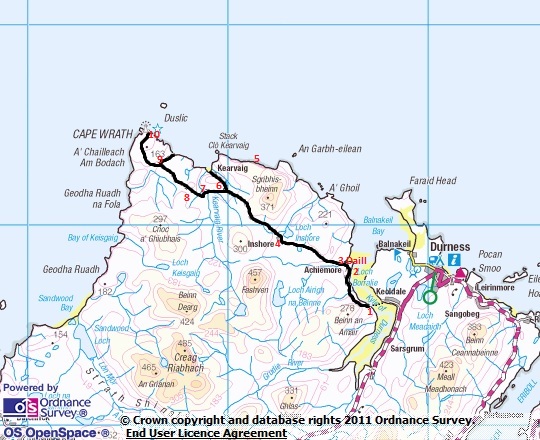
From the bus, several interesting landmarks can be seen (the numbers on the map, above, relate to the numbers below).
|
|
1. To access the Cape Wrath you must first take a ferry across the Kyle
of Durness which takes approximately 15 minutes.
On completion of the ferry trip there is an optional bus which takes you
to the Cape Wrath Lighthouse.
The bus trip takes approximately 40 minutes each way with time at the lighthouse to enjoy the scenery or
to visit the most remotest café in Britain - The Ozone Café.
The entire excursion takes approximately two and a half hours.
During the crossing amongst the beautiful scenery you are likely to see Common Seals as well as a range of other wildlife.
Daill beach is a beautiful secluded spot, easily accessed from the ferry point.
Just up from the ferry port on the Capeside, there is the old Ferryman's House on the left hand side of
the road (and which is visible from across the Kyle).
As it's name suggests, this house was originally
built by the Northern Lighthouse Board
to house their ferryman.
|
2.
|
|
|
|
|
The first MoD sentry post
|
The old Cape Wrath side school
|
The stone foundations which can be seen behind the first MoD sentry station by the side of the road was an old side school,
that was used when a family with children lived too far away from a main school.
From 1935 to 1938 there were around thirty five people living on the Cape Side and apart from the lighthouse keepers,
all the men were shepherds working for two local farms. In total, there were ten children attending the school,
which was last used in 1947.
Once there was a thriving population in this now desolate area - a world of difference to the Cape Wrath of
nowadays where, like many other small Highland communities, the houses lie sad and empty. Do the hundreds
of tourists who speed past Achiemore, Daill, Inshore and Kervaig ever give a thought to the families who
lived there and the way of life now gone? Like many places in the Highlands it was once a lively community, until the
people drifted away to less isolated areas.
|
3. The wooden "temporary" bridge was constructed by the Royal Marines in 1981. Prior to this, the bus carrying passengers to the
lighthouse would frequently stall at this point crossing the burn and passengers were expected to help push the bus out.
|
|
4.
The house here at Inshore is owned by the MOD. A large area of Cape Wrath is used as
a MOD bombing and targeting range. Although access is allowed to
Cape Wrath, there are restrictions when exercises are taking place. All possible measures are taken to keep
interference with the normal everyday activities of people living and working in the area to a minimum and
the ranges are only activated on days when noise and vibrations are estimated above certain levels. These
levels were ascertained with seismic, geological and noise reverberation level research commissions and
with meteorological reports on the day predictions are made as to the likely disturbance.
The presence of
military activity, which has a long history and is responsible for many disused brick buildings scattered
around, brings locally welcomed civilian employment.
The MoD has an ongoing conservation programme with the aim of monitoring the effect of bombing on the seabirds.
|
5. The Clo Mor cliffs are the highest cliffs on the British Mainland with a drop of 620 feet.
Just to the east there is a virtual sheer drop of 900 feet. These torridonian Sandstone cliffs are a major
breeding site for sea birds in the United Kingdom.
|
|
|
6.
|
|
The track leads down to Kervaig House, now used by the Mountain Bothies Association.
The bay in front of the house is reputed to be where the Norse men landed their boats. The bay is of outstanding natural
beauty and is highly recommended. You can access the bay by walking round the
coast from the lighthouse.
|
|
7. The yellow and black hut before the bridge is a sentry post for the MoD.
During exercises sentries are stationed stopping any walkers who may stray on to the range.
|
|
|
8.
|
|
Looking North east from here you can see Kervaig Bay and the sea
stacks. The stack is also known as the cathedral due to the
appearance of two spires (a closer view of which, can be seen in the picture 2 up from this).
|
|
9. The junction goes down to the lighthouse jetty at Clais Charnach (Latitude: 580 37'N, Longitude: 040 59'W)
where ships used to deliver the supplies for the lighthouse and population of the Cape Side.
This jetty is used nowadays as a landing point for military exercises, with SAS soldiers being set
ashore here. They then have to fend for themselves for up to two weeks in this remote and inhospitable area.
|
|
|
10.
|
|
|
|
|
|
Cape Wrath Lighthouse
|
The old Lloyd's Buildings (as seen from the lighthouse)
|
The north coast
|
The Lighthouse. The old buildings which can be seen up the hill over looking the Lighthouse, are the remains of
a signal station which was first used in 1930. All passing shipping had to signal the station giving such
information as cargo being carried, port of departure and E.T.A. Looking east from the lighthouse you can
see the sea cliffs stretching out towards Durness. These cliffs provide ideal habitats for many sea birds.
Please note : The operator is only liable for when passengers are in physical contact, within,
boarding or alighting our transport.
At all other times, people explore Cape Wrath entirely at their own risk.
Back to Top
|